استان ایلام یا به کُردی پارێزگای ئیلام، یکی از استانهای کشور ایران است که در باختر این کشور و در ناحیهای کوهستانی و نیمه گرم قرار گرفتهاست.
این استان از استانهای کمابیش جنگلی ایران است. شمال استان دارای اقلیم کوهستانی است اما در جنوب این استان دشتهای وسیع وجود دارد. مرکز این استان شهر ایلام است.استان ایلام از غرب با کشور عراق، از جنوب با استان خوزستان، از شرق با استان لرستان و از شمال با استان کرمانشاه همسایه است.
بیش از نود درصد منابع نفتی و گاز غرب کشور و یازده درصد منابع شناخته شده نفت و گاز ایران در استان ایلام قرار دارد. همچنین این استان در جایگاه دوم منابع نفت و جایگاه سوم منابع گاز کشور است.
استان ایلام به همراه استان خوزستان دارای طولانیترین مرز بینالمللی با کشور عراق است. استان ایلام در دامنه غربی سلسله جبال زاگرس قرار دارد. سرزمینی با آب و هوای متنوع و جاذبههای طبیعی و تاریخی کهن که به عروس زاگرس مشهور است. براساس اسناد تاریخی، این استان بخشی از تمدن باستانی عیلام بوده است. آثار تاریخی و کتیبههای باستانی موجود در شهر، نشانهای از قدمت ایلام هستند. پیش از دورهی پهلوی، به این استان لرستان پشتکوه گفته میشد اما در دوران پهلوی، با توجه به پیشینه تاریخیاش، آن را ایلام نامیدند.
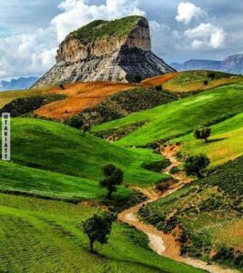
مناطق شمال و شمال شرقی استان ایلام کوهستانی و مرتفع هستند و نواحی جنوبی و غربی را زمینهای کمارتفاع تشکیل دادهاند. همین مسئله باعث تنوع جاذبههای طبیعی در آن شده است.
استان ایلام به سه منطقهی آبوهوایی تقسیم میشود: بخشهای کوهستانی شمالی و شمال شرقی با آبوهوای سرد و زمستانهای طولانی، بخشهای میانی با آبوهوای معتدل و جلگههای غرب و جنوب غربی با آبوهوایی گرمسیری. استان ایلام از ده شهرستان ایلام، آبدانان، ایوان، بَدره، درهشهر، دهلران، چَرداوُل، مَلِکشاهی، مهران و سیروان تشکیل شده است. 
Ilam Province or in Kurdish :Parêzgeha Îlamê is one of the 31 provinces of Iran. It is located in the west of the country, in Central Zagros, and is bordered by Iraq to the west, Khuzestan province to the south, Lorestan province to the east, and Kermanshah province to the north.
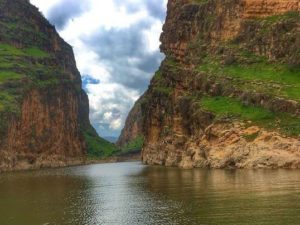
The largest city and also the provincial capital is the city of Ilam. Ilam is divided into 11 counties, 28 districts and 52 rural districts. Ilam province is situated at the southwestern edge of Zagros mountains. The most prominent mountain in Ilam province is Kabir Kouh, which is located in the eastern part of the province.The highest point in province, Kan Seifi peak with 2,775 m (9,104 ft) above sea level, is part of Kabir Kouh range. Ilam Province has a diverse linguistic presence, albeit having the smallest population in Iran. The predominant language is Kurdish, more specifically the Southern Kurdish. Luri is spoken in the southern parts of the province. Arabic is spoken in smaller settlements near the border to Khuzestan Province. Apart from some few springs here and there, such as Siah-Gav Twin Lakes near Abdanan, there are no major natural bodies of water in the province. There are, however, four dams that provide important drinking water, these include Ilam, Seymareh, Eywan and Doiraj . With about 31% of its territory covered with scattered to dense forests of mostly Persian oak, Ilam ranks 3rd in the country after Kohgiluyeh and Lorestan provinces, excluding the northern provinces of Mazandarn and Gilan. The Arghavan Canyon near Ilam is known for the pink blooms of the Judas-trees, which flower in Spring. The highlands and the forests of the province are the habitat of many animals including the endangered Persian leopard.Ilam is home to the endangered Spider-tailed horned viper, a unique species only found in Ilam province. Ilam province is considered as one of the tropical regions of the country, but due to difference in altitudes, temperature and precipitation, three different types of climate can be observed: 1-Mountainous areas of the north and northeast, which have cold climate and long winters. 2-The plains of the west and southwest of the province have dry hot climate. 3-Other areas have temperature to warm climate with hot summers and mild winters. Occasional heavy rainstorms in spring and autumn bring, sometimes, huge floods. The steep slopes of Zagros Mountains, soil type, lack of vegetation are among some of the reasons why Ilam province is prone to flooding. Ilam is occasionally affected by dust, especially in summers. It has become more frequent in the last ten years. The successive droughts of the recent decade in Iran and the long wars in Iraq and Syria have also exacerbated the issue. The name “Ilam” comes from “Elam”, the pre-historic civilization that ruled the area in modern southwest Iran from 2700 BC to 539 BC. Archaeological findings dates human settlement of the area to around 5000 BC. Ashurbanipal, the then king of Assyria, invaded Elam in 639 BC and totally destroyed it. The Elamites survived and continued to live in the area after the invasion. Between 612 and 546 BC, Elam was incorporated into the Median Empire and later into the Achaemenid Empire in 539 BC. During the Achaemenid Empire, Elam lost its independence forever and became the third province of the empire after Persis and Media. During the reign of the Medes, Achaemenids, Seleucids and Parthians, owing to its proximity to the districts of Hamadan, Kurdistan, Kermanshah, Lorestan and, most notably, Susa, the area and its settlements took on importance. During the Sassanid era, the present-day Ilam was composed of two states: Mehrjanqazaq in the east, which was the modern day Darreh Shahr and Masbasan in the west. The Rashidun Caliphate conquered Mesopotamia by 640 CE and later the whole Sasanid Empire by 643 CE and kept the control until their collapse in 661 CE. The Umayyad controlled the area until their own collapse in 750 AD, after which the Abbasid Caliphate took over and reigned for around two hundred years until 945 CE. After conquering the western Iran in 945 CE, the Buyid Dynasty ruled over this area until 1055. For 270 years, between 1155 and 1424, they reigned the Zagros Mountains, especially areas around Lorestan. Hazaraspids who are also known as Lorestan Atabegs were composed of two groups, the Little Lor, who were of Lor descent and Big Lor Atabegs who were of Kurdish descent. From 961 to 1015, the Ḥasanwayhid dynasty ruled over western Iran under the influence of the Buyid Dynasty. The Ḥasanwayhid dynasty was overthrown by the Annazids, who, with help of the Buyid dynasty, controlled the area until their collapse in 1116 CE. The Little Lor Atabegs or the Khorshidi dynasty ruled over the area for over 412 years, from 1184 to 1597 CE, after which Shah Abbas the Great executed the last ruler, Shahverdi Khan, and replaced Shahverdi’s nephew, Hossein Beyg/Khan, thus ending the rule of Little Lor and beginning of the Vali/Wali dynasty also known as Feyli Vali. During the Qajar era, Lorestan was divided into two regions: Poshtkouh (present-day Ilam province) with the center of Ilam city and Pishkouh (present-day Lorestan) with the center of Khorramabad. Poshtkhouh literally means “back of mountain” and it was due to the fact that Ilam was situated at the westernmost parts of the Zagros Mountains and to the rest of the country it was plainly considered at the back of mountains. From that point on, Ilam was ruled independently from Lorestan, and the governor reported directly to the central government, thereby ending Lorestan control of Ilam and Poshtkouh.
The two districts were later renamed “Deh-e Bala” and “Deh-e Pa’een”, which basically means the upper and lower villages. During the rule of Hossein Qoli Khan over “Deh-e Bala” (1863-1900 CE), it was renamed to “Hossein-Abad Poshtkouh”. Following the establishment of the Pahlavi dynasty in 1925, Reza Shah suppressed the local governments to consolidate his dominance. In 1928, the government forces took over Poshtkouh and Gholamreza Khan Feyli, the last Feyli governor left Poshtkouh without any resistance and went to Iraq, thus abolishing the rule of the Feylis in Ilam after 332 years. A year later, in 1929, “Hossein-Abad” was renamed to “Ilam” by the suggestion of Academy of Persian Language and Literature. After the Revolution, Ilam was of the main battlegrounds of the Iran-Iraq war for years. The war began with the Iraqi invasion of western and southwestern parts of Iran on September 22, 1980. As a border province, Ilam was a constant target for the Iraqi bombing campaign and suffered heavily in terms of economic infrastructure. The war left Ilam province devastated for years, making it one of the least developed provinces in Iran. The original inhabitants of Ilam were the Guitians and the Kassites, and with the arrival of the Aryans in Iran, the Medes settled in the Zagros region. Throughout history, many people have settled and ruled in the region and as the result, today, Ilam is inhabited by Kurds, Lurs and Laks . For the same reasons, the culture of the Ilamians is diverse, mostly a blend of many cultures. Embossed kilim is a combination of simple kilim and carpet knot in its text, which is considered as the most important and original handicraft in Ilam province. Ilam’s cuisine, like its culture is a blend of Kurdish and Lurish cuisines.
The largest sector of Ilam’s economy is agriculture, though much smaller compared to other provinces of Iran. With an estimated 14 trillion m3 of gas reserves and 17 billion barrels of oil reserve, equal to 6% and 11% of Iran’s reserves respectively, Ilam ranks 2nd and 3rd in the country in terms of gas and oil. The industry sector of Ilam’s economy is poorly-developed even non-existent. According to the latest statistics, Ilam is the least industrial province in Iran. In recent years, some efforts went into stimulating Ilam’s industry by building industrial towns and areas, providing encouraging opportunities for businesses such as cheaper land, utilities and tax. Since 2005, 8 such towns and 5 areas have been built. As of 2018, Ilam has one of the highest ratios of number of general practitioners to population in the country, ranking 2nd. There are 3.48 GPs per 10,000 population in Ilam province, the average of the country being 2.37. Ilam also has the highest ratio of dentists in the country. Despite the positively looking statistics when compared with other provinces, the medical facilities and expertise are unequally distributed in Ilam province; Ilam, the capital, serves as the medical hub in the province, hosting majority of hospitals, medical laboratories and specialist. One of the most known athletic figures of Ilam Province is Mojtaba Maleki, a two times gold medalist in World Powerlifting Championships in 2017 and 2018. He also has more than ten Asian gold medals. Maleki is the second person in the world to have squatted 500 kg raw with wraps.